Saturday 19 July 2014

Days 74 - 79: Cusco and Machu Picchu - Buying Brand Inca

Not sure where this is (?)... nice photo though!
We arrived in Cusco, along with the thousands, the night before the summer solstice festival - a matter of lucky timing.  The main square was over-run with celebrations which, at this stage, resembled the parade of athletes around the stadium at the Olympic opening ceremony, except that we weren't quite sure who the 'teams' were.  Nonetheless, we couldn't help falling for beautiful Cusco with its grand plazas, rows of white terraces, and blue balconies.  We weren't the only ones.  Cusco is packed, not only with backpackers but with much wealthier tour groups - and don't the clothing and jewellery shops know it.

The Inca "gate" to the
valley containing Cusco
The mad scrum to obtain free books
being handed out at the festival
The next morning our first-floor restaurant on the main square gave us a good view over the festivities - almost our only glimpse of the day.  Alas, we spent the rest of the time grappling with poor wi-fi, a disfunctional BA call centre and trying to nab cut-price places on a trip to the Galapagos.  At least we managed a couple of hours in the Inca Museum, which follows the pattern of other museums I have visited in Bolivia and Peru - exciting artefacts but dry and limited interpretation.  (I don't just want to know the number of millimetres in length of each piece of metal (I can see it in front of me); I want the story: how did it get there?  Why did that society use objects like this?)

Colonial Cusco rises on foundations built by the Inca empire.

Inca stonework eclipses the Sacred Valley
Magnificant Pisaq
The next day we bought our all-important Machu Picchu tickets then took a bus to Pisaq.  At five soles each (about a pound), it cost three percent of the price of getting to the celebrated Inca Royal Citadel.  But it turned out to be worth much more.  Pisaq is an amazing place.  It takes the Incas to find a ridge line, high in the hills, and see potential for a city - to see the steep slopes of a mountain and spot agricultural potential.  Terraces cover the hillsides while the ceremonial sites, temples and houses hug the hilltop.  Walking between the seven developed areas you get a trek and a journey to the past all in one - perfect for a couple of mountaineers. It was such a good day that it begged to be rounded off with a pisco sour (with papaya no less) so we drank one before splashing out another pound to return to Cusco.
Immaculate terracing (restored) at Pisaq
The beauty and size of Pisaq is striking
The next day took us to another Inca site, Ollantaytambo, complete with another round of faithfully-restored terraces and a temple complex made from immense stone blocks.  The drainage and water supply systems (of all things) wowed me.  Carefully-aligned grooves channeled water along each terrace and into each set of buildings.

'Weren't the Incas incredibly sophisticated?' said the voice in my head. Then another voice reminded me that we are looking at artefacts from an era only five hundred years ago and that technologies in many parts of the world were similarly advanced.  Because so little is known about the pre-Hispanic civilisations in South America, in the absence of written records, it's tempting to think of them in the way I might think about, say, the Ancient Greeks, as belonging to a distant past.  But five hundred years is hardly far distant.
Ollantaytambo
After wandering around the ruins it was time to go for the classic Inca meal of a Mexican wrap and a beer, then take the train to Aguas Calientes ('Machu Picchu' according to booking.com). With my train-spotter husband, I'm unqualified to comment on trains except to say that it was very plush, offered great views up the wooded gorge, had windows in the ceiling as well as the walls, and was over-run by noisy American high school kids.  Also, being a Peruvian train, our monstrous fare didn't even get us a carcass-free meal.

It's called a diesel railcar Susan!
The station at Aguas Calientes
Aguas Calientes had been sold to us as a dive, but there's something special (and a bit wrong) about staying deep in a wooded gorge with a mountain stream tumbling swiftly alongside.  Basically, it's a town in the path of a flash flood, present or future.  Until then, other types of liquid occupy the attention of visitors.  The phrase 'happy hour' is spoken here more often than in all of the cities of England combined.  In some restaurants it means not 'two for one' but 'four for one'.  FOUR for one?!  This wasn't the time to drink the night away however, as we planned to take the 5:30am bus to Machu Pichu the next morning.

Susan locates the sacred city
What is there to say about Machu Picchu that hasn't already been said?  It lives up to its reputation (including for being over-run).  To escape the crowds, we bought tickets for the mountain above Machu Picchu - not the small peak of Huayna Picchu but the higher peak whose 600m of ascent puts off most visitors.  We were feeling pretty fit so we skipped to the top in forty minutes, passing a number of puffing bodies on the lower slopes.  It was a beautiful climb up a steep stone-paved path through the forest, turning into something more closely resembling a stone ladder near the top.  When we arrived on the summit, only two people were there before us.  We sat down with them, surrounded by swirling mist through which tantalising glimpses of surrounding peaks appeared.  Eventually the fog began to lift and Machu Picchu emerged from the cloud inversion.  With every raising and lowering of the cloud, cameras whirred.  Whatever its archeological merits, it is impossible not to be wowed by Machu Picchu for its lofty location, perching amidst the clouds.

First glimpses of Machu Picchu from
Machu Picchu mountain
Steep terraces
Huyana Picchu is the mountain behind

With the air clearing, we jogged back down the steep path and emerged from the trees onto terraces immediately overlooking Machu Picchu.  Here we sat down for a busy half hour's gawping.  This proved so strenuous we decided we needed lunch and a beer to fuel another gawping session in the afternoon.

The agricultural terraces around Machu Picchu are so steep and narrow that I couldn't help wondering how many men had been lost overboard, fetching up as Inca skeletons in the valley, while building them.  There are even a few cheeky terraces built on what I would describe as a cliff (but the Incas would appear to describe as a field) near the summit of Huayna Picchu.  I would want a rope and my climbing harness to venture there; the Incas, by contrast, presumably thought that a scythe was sufficient equipment for the location.  But did they really need to build terraces right on the top of the mountain?  Surely this is the definition of showing off.

Temple of the Condor. Obvious, no?
When our jaws were tired from dropping, we returned to Aguas Calientes for a celebratory glass of guess which drink?  - yes, pisco sour - before returning to Cusco.  Time to flop.

Machu Picchu busy eclipsing Pisaq
After a couple of days to recover from the excitements of Peru so far, and the asthma attacks induced by damp hostels, we finally rolled out of Cusco.  Inca statues passed us on the way.   As in so many similarly adorned towns, their manly figures lined the roadside complete with rippling muscles, broad chests and completely symmetrical facial features.  No cleft lips for the Incas.  No weedy forearms.  No bellies.  No sagging skin.  It's official - the Incas were hunks.  All of them.

This, I suppose, is the brand that so many travellers are here to buy.  Brand Inca.  You can not only walk the Inca trail but eat in the Inca restaurant, go Inca rafting, stay in the Inca Hostel, take the Inca bus (they had buses?), use the Inca toilet, get up some adrenalin on an Inca biking trip, dare the Inca zip line or drink Inca Kola (which looks like urine and tastes somewhat worse).  I hope there are some Inca skeletons in the soil below Machu Picchu tossing in their graves, rattling at every turn.  How can we have turned an archaeological study into this?  Yet we too bought a fair few Brand Inca products on our trip and loved them (Inca Kola excepted).  And all the while, the poor old Tiwanaku continue to be ignored!

The train ride to Machu Picchu is an amazing ride clinging to the edge of a narrow gorge
Ever seen trains parked in the middle of town? Welcome to Aguas Calientes
Train running through the centre of town 
A statue of C3PO in Cusco
Beautiful Cusco

Days 69 - 73: Arequipa and Colca Canyon

Choosing lunch
When we arrived in Arequipa, Southern Peru, we could tell we had crossed a national border.  After grid-locked La Paz, the traffic here flowed freely, and the centre of the town showed levels of wealth that we haven't seen since we left Sucre.  On the downside, the chains have come back into the picture.  I had forgotten what the logos of Starbucks and MacDonalds look like; now they offer me coffee and burgers and ice cream as I turn a street corner.

We paid a visit to the market where smoothie stalls abounded (strawberries, oranges, mangoes and passion fruits all in one drink? - yes, please).  We bought the world's biggest avocados and a cheese the size of my head and a box of fudge.  ("Don't make me eat any chocolate," says Guy, while stuffing himself with chocolate fudge.)  Then we bought mandarins the size of peaches and tomatoes.  Back on the sunny roof terrace of our hostel - the nicest place we have stayed in South America bar Easter Island - we ate our tastiest meal in weeks.

Fruity!
Very Fruity!
After gluttony, time for prayer.  We visited Santa Catalina's monastery, which makes up its own high-walled village within Arequipa city.  Its streets and courtyards are filled with flowers and lined with buildings coloured in royal blue and dust red.  Lean against them and you retain the red dusting on your clothes.  Turn your camera off and you will immediately turn it on again.  The monastery is photogenic, peaceful, easy to lose yourself in for an hour or three.

Santa Catalina Courtyard
We took a guided tour and found out about the oh-so-egalitarian lives of the nuns.  They lived far enough away from Rome "to get away with it", according to our guide.  Nuns' families paid an enormous sum of money to have a daughter admitted to the monastery, although less than the cost of a dowry - God comes cheaper than a husband, it seems.  Once there, your status depended on the riches you brought with you.  Your family had to build you a house inside the monastery complex and standards varied.  Some homes were shared by several nuns; others belonged to one individual.  Some had servants; others didn't.  All very equal in the eyes of The Lord!

Volcan Misti as seen from the monastery in Arequipa
The regularity of earthquakes in Arequipa had a significant influence on interior design.  Every nun's bed was located under a wide archway - the strongest architectural features of the building.  I also liked the pots of porous stone through which water dripped over a period of hours for purification.  La Paz, take note!

Feed the birds?
Colonial Arequipa
For the remainder of the afternoon we wandered around the stone buildings in the centre of Arequipa and sat out on the street drinking Pisco Sour, enjoying the warmth, and avoiding pubs showing World Cup football matches (ie. all of them).  England lost to Uruguay yesterday; neither Peru nor Bolivia is playing; and Guy would appear not to know even the most basic rules of football (like how long a match lasts, or the difference between a free kick and a penalty - clearly he had an insufficiently mis-spent youth) so interest is limited.

Susan in the clothes washing
area of the Monestary
First views of Colca Canyon
The next day we had to brace ourselves for the earliest start of the trip - a 3am bus to Colca Canyon.  Once day had dawned, the mini-van dropped us at a viewpoint on the rim of this vast green-and-rocky cleft where we spent half an hour watching condors circling below us.  Then we continued to the village of Cabanaconde where we optimistically left our baggage behind the counter of a shop for a couple of days before setting out on the trail that descends into the canyon.

The trail drops just over a thousand metres vertically by a route that changes at the whim of rockfalls and landslides that periodically wipe sections away.  A fair bit of work had clearly gone into propping it up, although we didn't always one hundred per cent trust the repair work.  Still, the views down to the river, almost vertically below us, were beautiful, and Guy had plenty of opportunities to wax lyrical about geological processes, so we were both happy.

After pic-nicking beside the river we walked through the village of San Juan - an oasis of orchards, sweetly-scented with all things alive and growing.  It's the kind of place where you walk under a tree and wonder whether it is going to throw an avocado or an orange at you.  The air is warm and balmy.  Water trickles.  Insects hum.

But before long we had left the village behind and started climbing the far side of the canyon to a scenic beer stop (accompanied by dozens of guinea pigs on death row - they feature prominently on menus here) before descending again.  Just before nightfall we reached the lush oasis of Segalle - surely one of the villages with the highest number of swimming pools per inhabitant on the globe?

The river at Segalle 2
The river at Segalle 1


Next morning, we re-climbed the canyon's sides and reached Cabanaconde at 11am, just in time for a refreshing peach juice after the sweaty ascent.  Fortunately our baggage had not been sold over the shop's counter for a few Peruvian soles and we reclaimed it gratefully.  The rickshaw-wallahs of Chivay, where we spent the night, would not have to miss out on transporting it after all.  Next stop, Cusco.


Descending into the canyon
The Oasis of Segalle
Columnar jointing in the volcanic rock is visible throughout the canyon

Days 58 - 60: Lake Titicaca

Car ferry, Bolivia-style
The four-hour bus ride to Copacabana, on the shores of Lake Titicaca, crosses a ribbon of water about half a mile wide.  As buses can't swim, the passengers had to disembark and cross on a small boat that coughed several times before it chugged into motion, then rolled across the channel as the waves hit it side-on.  But the passengers had an easy time of it compared to the buses, which drove onto a raft penned-in by a low timber rail nowhere near high enough to prevent the vehicle from going overboard.  We sidled up to the rafts to take a closer look.  The 'floor' of each one was 'discontinuous' (being diplomatic); 'half-rotten' (being frank).  The wisdom of leaving our bags on board began to look limited.  Twenty minutes later we were on our way again, safe and sound, but I wouldn't be surprised if the shivering timbers of the odd bus or three had been left behind at some point, quaking on the bottom of the channel.

How many trucks and buses end up in the drink I wonder?
After an hour in faux-quaint Copacabana, we took the boat across Lake Titicaca to the Isla del Sol.  The journey was slow but why hurry?  The lake was a deep blue with snow-capped mountains behind; one of the most beautiful contrasts I have seen.  We continued to gape at the same views that evening as we sat drinking tea in a cafe high on the slopes of the island, then on the balcony of our hostel.  Bliss.

Copacabana
The next morning, the prospect was not quite so good.  Guy was feeling fluey; I had succumbed to food poisoning.  But we had a deadline to be back in La Paz for a trek with Tim and Jenny so this was our only full day on Isla del Sol.  Despite our ailments, we set out to walk the length of the island to the Inca ruins at the far end.

The path was well-made and followed the crest of the hills for a couple of hours, with views to either side.  Whatever food we'd been given in the last twenty-four hours was less well-made and by the time we made it to the Inca ruins I couldn't do much except roll around on the ground and groan - not a propitious welcome to Inca-dom.  We staggered back along the path in lower spirits than on the outward journey and collapsed onto our hostel bed.  The evening saw a farewell visit to  the same restaurant as yesterday, which looked out on the sunset and served delicious home-made food oh-so-slowly.  But again, why hurry?  The sun went for a bathe, candles flared, the night was quiet with nothing to do but relax until morning.  I splashed out on a full flask of mint tea for dinner then we called it a day.

The next morning we retraced our steps to La Paz, enjoying the view of snow-clad Huayna Potosi towering over the city as we descended into its chaotic streets.  Funnily enough, it felt like a home-coming of sorts.


The Cordillera Real provides the backdrop, Isla del Sol the terraced landscape in the foreground
The "Inca Trail" along the spine of the Isla del Sol
Harbour on the far side of the island


Days 62-67: Six days in the Cordillera Real (or a 6000er with a 4 day walk-in).

Condoriri Base Camp at Ch'igara Quta

As one of the most easily accessed ranges in the Andes, it would have been rude to pass by La Paz and not to incorporate a trek or a peak in the Cordillera Real. As it happened we managed to include both and all in the course of less than a week!


Having already attempted four summits in the Andes and only succeeded on two (largely due to the weather), our original plan for the Cordillera Real was to shun summits and head to the northern end of the range for a circular eight day trek known as the “Illampu Circuit”.

A three day jeep tour of the Salar de Uyuni (the giant salt flat in southern Bolivia) introduced us to Jenny and Tim, another “mad for it” couple from London, who were up for an adventure and keen to summit their first 6000er.

Susan and I were already well acclimatised after summiting San Miguel de Palermo (6000m) in the Nevado de Cachi range (northern Argentina) and a couple of volcanos in the Atacama. Jenny and Tim, however, needed a bit more time above 4000m to complete their acclimatisation. A drunken night at the Salt Hotel (you’ve heard of the Ice Hotel?, same idea!) and the plan was hatched. We’d do a five day trek followed by a three day ascent of what The Lonely Planet describes as “one of the easiest 6000m mountains in the world”: Huyana Potosi (6088m).

Despite The Lonely Planet’s quip, at AD-, Susan and I felt that the route up Huyana Potosi was outside of our limited Alpine experience (despite having previously summited two 6000ers unguided). To help with the trip, we lined up logistical support for the trek from Eduardo Mamani from Bolivian Mountain Guides, as well as guides for the attempt on Huyana Potosi.

Ten days later and we rendezvous with Jenny and Tim in La Paz. Susan’s on her first bout of “Boliva Belly” and I’m on my second. We’re in no fit state to start hiking. Our health, combined with the fact that Jenny and Tim need to rent gear and Eduardo’s gear rental supplier is having “legal problems” means that we hastily re-arrange the trek to a four day trip whilst the ascent of Huyana Potosi shrinks to two days.

Access to the Cordillera Real from La Paz is from the south west: from one of the many valleys running perpendicular to the range. The plan for the trek is to hop from one valley to another camping next to the many lakes dotted around the area taking in one or two 5000m passes per day. To fit the trek into four days, we plan for Eduardo to drop us at Laguna Ajwañi. We will trek independently east along the range and arrive four days later at one of the numerous refugios that have been set up at the base of Nevado Huyana Potosi to take guided groups up the mountain. Eduardo and another guide will meet us at the refugio the next morning (Day 5) for the trip to high camp and on to the summit (Day 6).

We obtain a poorly printed local map (gridlines at 45 degrees to the paper edges and an unknown scale of about 1:100,000) whilst Eduardo explains the route and the overnight camps. Less than 24 hours later and we are bumping along a rough track in Eduardo’s Landcruiser with Tim in the front seat looking green, the latest victim of Bolivia food poisoning roulette.


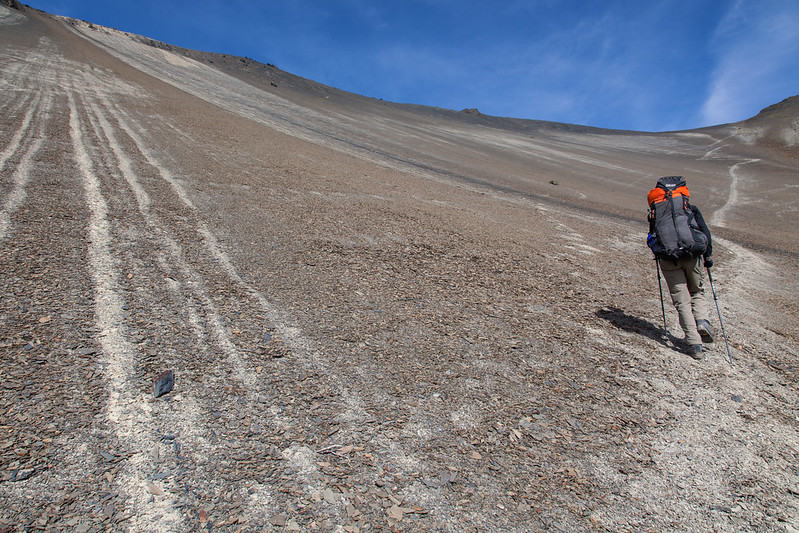
We had started much later than planned as the “legal problems” faced by Eduardo’s Swiss gear-rental partner had caused considerable delay back in La Paz that morning. We ford a river and then pull off the track. Eduardo jumps out, wanders 50m and looks apprehensively at the hills. “First pass” he says and starts driving over scrub bushes towards what we had planned to be the first pass of the day. The ground steepens and we begin to wonder just how far he’ll drive us. Fortunately he stops just short of a 45 degree scree slope and we bundle out relieved to be finally starting the trek.

Setting Off
With only 80m or so of ascent left, the first short pass over to Laguna Sistaña was very straightforward albeit a bit of a slog at 4900m altitude. Unused to the height after spending the last week down in the jungle, Jenny got a fit of the wobbles just after the pass but was quickly resuscitated with help from Tim, fizzy drink and biscuits.
The second pass over to Juri Quta (Quta means “lake” in the local Aymara language) required more effort but was still only about 250-300m of ascent. Still, this proved a strain for Tim’s fragile stomach and by the time we reached our camp by the lake we had a broken Tim on our hands. The rental tent from Eduardo proved large enough for 3-4 people so became the logical place to congregate for dinner.

Laguna Sistaña
With food, a couple of games of Sopio and a good night’s rest Tim gradually turned back from a shivering lump in a sleeping bag into a fit trekker. Guy on the other hand, had regressed from fit trekker to shivering lump. Such is the callousness of Bolivia food poisoning roulette! This was a pity as today was to prove the best day of the trek.

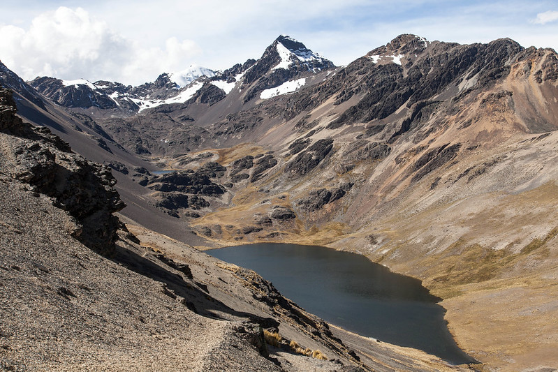
Heading north up the west side of Juri Quota, the path climbs up the lateral glacial moraine to reach a beautiful glacial lake at about 5000m. The backdrop to the lake is the fabulous Cerro Condoriri: a bergschrund-rimmed central pyramid with two satellite knife edge ridges forming the head and wings of the Condor. After a brief lunch we start the most technical part of the trek, a rock scramble up to the pass with short traverse across a 20m drop that was probably about a grade 3 scramble. Not so much fun with heavy packs, big boots and “Bolivia Belly”!

At the top of the pass, off to one side is a small subsidiary summit (Cerro Austria 5300). We leave bags at the pass under Guy’s watchful, sick eye and, liberated of weight, we speed to the top. The summit reveals stunning views of Condoriri, Alpamayo and further off to the east the imposing near-vertical west face our destination: Nevado Huyana Potosi.
Racing the sun, we descend to camp at Ch’igara Quota and in the twilight run into Eduardo’s nephew Pedro guiding an Australian couple on Pequeño Alpamayo. The next morning over breakfast we meet one of the Australians, sick and returning to camp having abandoned the climb after an alpine start and getting halfway up the glacier. We empathise as it turns out that she is also suffering from “Bolivia Belly” combined with a nasty cold. Fingers crossed our tummy problems sort themselves out before Huyana Potosi!

Approaching the pass above Ch'igara Quta.
Trek day three is the toughest yet. Two 5000m passes and around 25km of walking. We lose the path. Repeatedly. The map is barely detailed enough to know which valley we are in which is about as good as it gets. Night falls and the whole tired team are humping along a track trying to find the camp at Maria Lloco base camp. We know that there is at least one other group camped there that night so how come we can’t see head torches? Guy turns on his light in the hope that the gesture is reciprocated by the guys at camp. Luckily it is and we stumble into camp about an hour after sunset. Strangely this is the only camp we have to pay for (5 Bolivianos each) and at least half of the group are glad of the long drop toilets!

We have low expectations for the last day with it being a bit of a “filler” to get us to the refugio at the base of Huyana Potosi. Eduardo has already warned us about the prospect of walking a chunk of it on a road. As it turns out, the pass is as picturesque as any we’ve seen and we hardly touch the road as we contour round into the Rio Zongo valley reaching the Refugio in early afternoon.

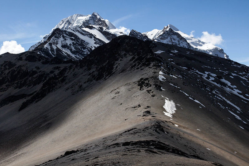
The West Face of Huyana Potosi
(as seen from the pass above Ch'igara Quta).
It turns out that Huyana Potosi is a popular summit. Very popular. There are no less than five refugios at around 4800m next to the road with a couple more under construction. The one we stayed at was run by Señora Elvira and had something of the feel of a Bolivian Fronwydyr (complete with bacterial water!). In broken Spanish we explain our situation and ask for beds and are provided with the attic room (think Fronwydyr again). A comfortable night ensues and we are sitting around drinking coffee when Eduardo arrives about 10am with our second guide whose name I am embarrassed to say I can’t remember.

It’s a short hike up to the upper Refugio built on rock at one side of the glacier at about 5200m. Ten years ago, this didn’t exist and neither did the other two built nearby. This just goes to show the power of Lonely Planet. This is borne out by talking to the other ascentionists we meet there. Of the 20-30 Westerners staying with us, all of the teams are backpackers bar four visiting Spanish mountaineers. It’s obviously a highly commercial mountain for Eduardo who personally guides three teams a week to the top. All of this gives me shivers as I think about the very steep, exposed summit ridge and what it will probably mean to have to pass another group en-route. We spend the rest of the afternoon practising skills on the glacier (it’s new for Jenny and proves a good refresher for the rest of us).

Huayana Potosi from the final pass (south) on Day 4
Forget any kind of “hut etiquette” as one of the guides slaps the light on at shortly after midnight. We’re due to wake at 1.30 and be off for 2.30 so this is an unwelcome sleep interruption. The Westerners are no better: chatting loudly over breakfast at the other end of the room. Their lack of etiquette suggests none of them has experienced being in a hut before with other people doing an Alpine start. Drowsily, we join them, gear up and don harnesses. As the last team out of the hut I don’t relish the prospect of passing the others on the ridge coming back.

Onto the glacier and we see the Spaniards (four on a rope) heading off as we fix crampons. With torches and the benefit of an almost full moon, we head off unroped following Eduardo with our other guide bringing up the rear. After an hour of soloing on 45 degree slopes, we reach the Bergschrund. I whisper to a nervous Susan: “You might have to ask for a rope rather than expect to be given one”. Eduardo must have been reading my mind as he breaks out the ropes (one per guided pair). The last snow was two weeks ago which has given plenty of time for the snow to form into nice névé and for an established path and steps to be cut. Never-the-less, we are all climbing to make it over with front points and picks in operation. Not so easy huffing and puffing at 5600m!

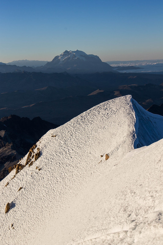
The south summit of Huayana Potosi
as seen from the north summit
(with Illumani in the background)
Dawn breaks and we have made it to the foot of the summit ridge. We pass a guided French couple who’ve aborted and are on their way down suffering from the altitude. Torches can be seen on the ridge leading to the summit. At this point, Eduardo points to the 70 degree snow slope to the left side of the ridge: “This way, it’s safer” he says. I feel as if a great weight has been lifted as the prospect of passing people on the ridge recedes. The feeling is short-lived, however, as I realise just how steep snow can be. Neither Susan nor I have moved together on terrain this steep before without pitching and we trust our feet (and our guides) as we take the final steps towards the summit.

Where we are at the tiny north summit is slightly higher than the south but is seriously corniced and Eduardo warns us back from the edge. There is probably space for 4-5 people and that’s about it. We take some photos and prepare to descend. “You first” he points to me. Surely not! “Um, someone else prefer to do it?” I mumble. Egged on, I start the descent conscious of every foot step and that any trip will send myself, Susan and our guide straight down the slope. We make it down without incident to the foot of the slope by which time the sun is well and truly up. We de-layer and gulp water and chocolate. Phew, we made the difficult bit!

Descending is a breeze and we are back at the hut by mid morning eating soup and packing our sleeping bags for the final bit of descent. By mid afternoon we are sitting in fumes in La Paz traffic dying to get to our hostel and retrieve our bags. Like Paddington Bear after his journey from “Darkest Peru”, we can’t decide whether to drink beer or shower first. To Guy’s disappointment, showers win out but it’s cheers all round as we hit the next-door bar and watch the final five minutes of world cup football.

La Paz and Illimani